Icy Commute and Wintry Mix: Louisville Braces for a Messy Monday Start
Morning Ice Risk and Commute Concerns
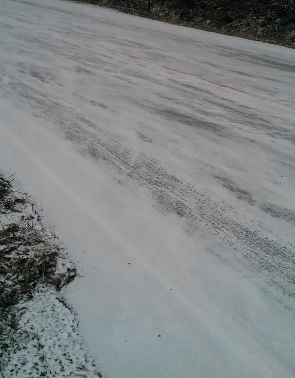
Louisville is waking up to a challenging Monday morning as a messy wintry mix settles over the metro area. According to the latest reports for March 2, 2026, commuters should prepare for slick conditions, particularly during the early hours. Forecasters have identified a 40% to 70% risk of an ice glaze forming on bridges, overpasses, and elevated surfaces. A combination of freezing rain, sleet, and light snow is expected to move through the region before 10:00 AM. While ground temperatures have remained somewhat warm, the National Weather Service warns that elevated roadways could become treacherous quickly. Drivers are urged to allow for significant extra travel time this morning, especially along and north of the Interstate 64 corridor.
Midday Transition to Steady Rain
As we move into the late morning hours, a slight rise in temperature will shift the precipitation from a frozen mix to steady rain. By midday, the mercury is expected to climb toward a high of approximately 42°F. The transition may be messy, with light slushy accumulations possible in north-central Kentucky. Rainfall is expected to be consistent through the afternoon, with a 90% chance of precipitation overall for the day. Total precipitation could be significant, so ensure your gutters are clear and you have your rain gear ready for any outdoor activities.
Evening Outlook and Wind Conditions
By Monday evening, the intensity of the showers will begin to taper off. Light rain is expected to persist through the early evening hours before transitioning into a mainly cloudy night. The temperature low for tonight will dip back down to 33°F. Residents should remain cautious of any wet patches on untreated surfaces that may refreeze as temperatures approach the freezing mark overnight. Winds will remain relatively light throughout the day, coming from the east at 8 to 11 mph, though the damp conditions will make the afternoon high feel closer to the mid-30s.
Severe Weather Awareness Week
It is also important to note that March 1–7 marks Severe Weather Awareness Week in Kentucky. While today’s primary concern is the wintry mix and ice, this is an excellent time for Louisville residents to review their emergency safety protocols. Consider the following safety steps today:
- Ensure you have multiple ways to receive weather alerts, such as a NOAA weather radio or smartphone apps.
- Check your vehicle's emergency kit for winter supplies like blankets and flashlights.
- Prepare for the upcoming statewide tornado drill scheduled for Wednesday, March 4.
Stay weather-aware and exercise caution on the roads today as Louisville navigates this cold and wet start to the week.

Chilly Rain and Breezy Skies: Grab the Umbrella, Louisville

Louisville expands multi-agency enforcement plan to identify repeat gun offenders linked to violent crime patterns

Yonutz Fantastical Donuts and Ice Cream plans second Louisville shop in the Highlands neighborhood