Louisville area faces gusty winds, rain and potential strong thunderstorms Thursday evening into overnight
What forecasters are watching for Thursday
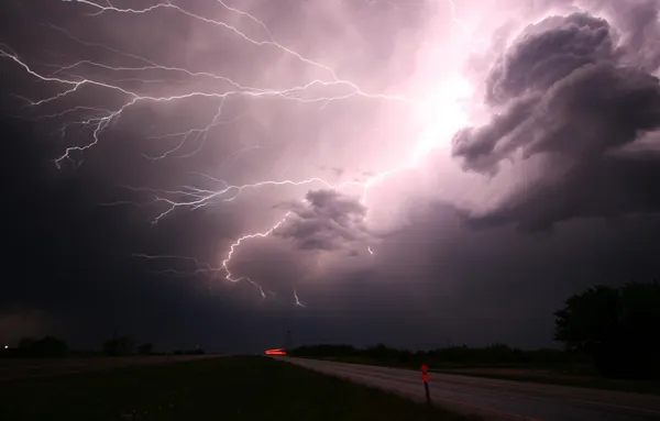
The Louisville region is heading into a more active stretch of weather as a strong storm system moves through the Ohio Valley, bringing periods of rain, gusty winds and a window for strong thunderstorms late Thursday.
The timing currently centers on Thursday evening through the early overnight hours (Feb. 19), when a cold front is expected to push in from the west. Forecast confidence is highest that the area will see widespread showers and thunderstorms, with the possibility that a subset of storms could intensify as the front arrives.
Primary threats: wind, heavy downpours, and localized impacts
The main severe-weather concern with this setup is damaging straight-line wind, which can bring down tree limbs, displace unsecured outdoor items and contribute to scattered power outages. Brief heavy rainfall is also possible in stronger storms, which can reduce visibility quickly and cause ponding on roads.
While hail and an isolated tornado cannot be ruled out, current indications suggest wind is the leading hazard if storms reach strong-to-severe levels in the Louisville metro and surrounding counties. The highest storm intensity may favor locations west of Interstate 65, where storms may arrive earlier and with less weakening.
Why Thursday could turn active
The developing pattern features a low-pressure system and an advancing cold front, a classic combination that can lift warm, moist air and organize thunderstorms along a line. Earlier warmth and gusty south winds ahead of the front can help provide energy for storms, while stronger winds aloft can help storms maintain structure.
Even outside thunderstorms, breezy to windy conditions are expected around the system, which can make driving more difficult for high-profile vehicles and can increase the chance of damage if storms produce stronger gusts.
Possible shift to colder weather after the front
Behind the system, colder air is expected to move in. Forecasts indicate rain could transition to snow in parts of southern Indiana and portions of Kentucky east of Louisville Wednesday night into Thursday, with light accumulations possible mainly on elevated and grassy surfaces. By Thursday, colder, windy conditions with snow showers are possible north of the Kentucky parkways.
How to prepare
- Secure loose outdoor items before Thursday evening, including trash bins and patio furniture.
- Charge phones and backup batteries ahead of the storm window in case of power interruptions.
- If thunder is heard, move indoors; avoid windows during any warnings.
- Plan for slower travel Thursday evening and overnight due to heavy rain bursts, gusty winds and reduced visibility.
Timing remains the key uncertainty: the strongest storms are most likely late Thursday evening into early Friday morning, but the exact arrival and intensity will vary by location.